Back مقاطعة سونوما (كاليفورنيا) Arabic مقاطعة سونوما ، كاليفورنيا ARZ Sonoma qraflığı (Kaliforniya) Azerbaijani Sonoma County, Kalifornien BAR Санома (акруга) Byelorussian Сонома Bulgarian সোনোমা কাউন্টি, ক্যালিফোর্নিয়া BPY Comtat de Sonoma Catalan Сонома (гуо, Калифорни) CE Sonoma County CEB
Sonoma County, California | |
|---|---|
| Motto(s): "Agriculture, Industry, Recreation" | |
 Interactive map of Sonoma County | |
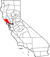
 Location in the state of California | |
| Coordinates: 38°31′N 122°56′W / 38.51°N 122.93°W | |
| Country | |
| State | |
| Region | San Francisco Bay Area |
| Incorporated | February 18, 1850[1] |
| Named for | the city of Sonoma |
| County seat (and largest city) | Santa Rosa |
| Government | |
| • Type | Council–Administrator |
| • Body | Sonoma County Board of Supervisors |
| Area | |
| • Total | 1,768 sq mi (4,580 km2) |
| • Land | 1,576 sq mi (4,080 km2) |
| • Water | 192 sq mi (500 km2) |
| Highest elevation | 4,483 ft (1,366 m) |
| Population | |
| • Total | 488,863 |
| • Density | 280/sq mi (110/km2) |
| Time zone | UTC−8 (Pacific Time Zone) |
| • Summer (DST) | UTC−7 (Pacific Daylight Time) |
| Area code | 707 |
| FIPS code | 06-097 |
| GNIS feature ID | 1657246 |
| Website | sonomacounty |
Sonoma County is a county in the U.S. state of California. It is located north of the San Francisco Bay. It is the northernmost of the nine San Francisco Bay Area counties.[4][5] Sonoma County is surrounded by 4 counties: Marin County to the south, Mendocino County to the north, Lake County to the northeast, and Napa County to the east.[6] The county seat is in Santa Rosa.
Sonoma County was one of the original counties formed when California became a state in 1850.[7]
The population was 488,863 in 2020.[3]
- ↑ "Chronology". California State Association of Counties. Archived from the original on January 29, 2016. Retrieved February 6, 2015.
- ↑ "Cobb Mountain-Southwest Peak". Peakbagger.com. Retrieved February 4, 2015.
- ↑ 3.0 3.1 "QuickFacts: Sonoma County, California". U.S. Census Bureau. Retrieved May 10, 2023.
- ↑ "San Francisco Bay Area Vision Project". Bayareavision.org. Archived from the original on October 29, 2013. Retrieved November 4, 2011.
- ↑ "The Association of Bay Area Governments". Abag.ca.gov. April 14, 2011. Retrieved November 4, 2011.
- ↑ "California County Map". CSAC.org. California State Association of Counties. 2014. Retrieved 2015-09-22.
- ↑ "California County History". CSAC.org. California State Association of Counties. 2014. Retrieved 2015-09-22.


