Back مقاطعة سانت تاماني (لويزيانا) Arabic St. Tammany Parish, Louisiana BAR সেন্ট তাম্মনী পারিশ, লুইসিয়ানা BPY Séng Tammany Gông (Louisiana) CDO Сент-Таммани (кӀошт, Луизиана) CE Saint Tammany Parish CEB St. Tammany Parish, Louisiana Welsh St. Tammany Parish German St. Tammany Parish, Louisiana English Parroquia de St. Tammany Spanish
St. Tammany Parish | |
|---|---|
 St. Tammany Parish Justice Center | |
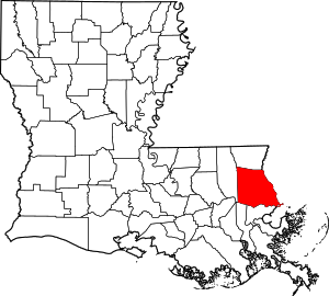
 Location within the U.S. state of Louisiana | |
 Louisiana's location within the U.S. | |
| Coordinates: 30°24′N 89°58′W / 30.4°N 89.96°W | |
| Country | |
| State | |
| Founded | October 27, 1810 |
| Named for | Indian Chief Tamanend |
| Seat | Covington |
| Largest city | Slidell |
| Area | |
| • Total | 1,096 sq mi (2,838 km2) |
| • Land | 845 sq mi (2,189 km2) |
| • Water | 250 sq mi (648 km2) 22.9% |
| Population (2020) | |
| • Total | 264,570 |
| • Density | 313/sq mi (121/km2) |
| Time zone | UTC−6 (Central) |
| • Summer (DST) | UTC−5 (CDT) |
| Area code | 985 |
| Congressional district | 1st |
| Website | www |
St. Tammany Parish (French: Paroisse de Saint-Tammany) is a parish located in the U.S. state of Louisiana, in the New Orleans metropolitan area. The population was 264,570 in 2020, making it the fourth-most populous parish in Louisiana.[1] The parish seat is Covington.[2] The parish was founded in 1810.[3]
- ↑ "QuickFacts: St. Tammany Parish, Louisiana".
- ↑ "Find a County". National Association of Counties. Retrieved 2011-06-07.
- ↑ "St. Tammany Parish". Center for Cultural and Eco-Tourism. Retrieved September 6, 2014.