Back Visayas Afrikaans بيسايا Arabic Visayas AST Visay adaları Azerbaijani Visayas BCL Visayas Breton Visayas Catalan Visayas CBK-ZAM Kabisay-an CEB Visayské ostrovy Czech
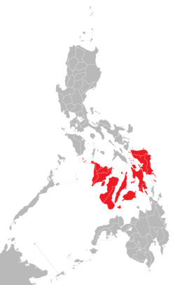
 Location of the Visayas within the Philippines | |
 | |
| Geography | |
| Location | Southeast Asia |
| Archipelago | Philippines |
| Major islands | |
| Area | 71,503 km2 (27,607 sq mi) |
| Highest elevation | 2,465 m (8087 ft) |
| Highest point | Mount Kanlaon |
| Administration | |
| Regions | |
| Largest settlement | Cebu City (pop. 964,169) |
| Demographics | |
| Demonym |
|
| Population | 21,155,014 (2021)[1] |
| Pop. density | 292/km2 (756/sq mi) |
| Ethnic groups | |
The Visayas or Visayan Islands (Cebuano and Wáray-Wáray: Kabisay-an, Tagalog: Kabisayaan, Spanich: Bisayas), is one of the three principal geographical divisions of the Philippines; the other two divisions are Mindanao, to the south, and Luzon, to the north.
People living in this islands are called Visayans.
- ↑
Census of Population (2015). Highlights of the Philippine Population 2015 Census of Population. PSA. Retrieved 20 June 2016.
{{cite encyclopedia}}: CS1 maint: numeric names: authors list (link)