Back Pulo Wake ACE Wake-eiland Afrikaans Wake ALS جزيرة ويك Arabic Ueyk rifi Azerbaijani Уэйк Bashkir Wake BAR Wake Island BCL Уэйк Byelorussian Ўэйк BE-X-OLD
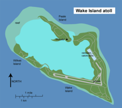
 Map of Wake Island | |
 | |
| Geography | |
|---|---|
| Location | North Pacific |
| Coordinates | 19°18′N 166°38′E / 19.300°N 166.633°E |
| Total islands | 3 |
| Area | 2.85 sq mi (7.4 km2) |
| Coastline | 12.0 mi (19.3 km)[1] |
| Highest elevation | 20 ft (6 m) |
| Highest point | Ducks Point |
| Administration | |
| Demographics | |
| Population | 0 permanent, 100 temporary[2] |

Wake Island is an atoll (a type of island) in the Pacific Ocean, near Hawaii. It is controlled by the United States Army and United States Air Force. It is a territory of the United States, part of the United States Minor Outlying Islands. From December 1941 to August 1945 the Empire of Japan ruled Wake Island.