Back مقاطعة والاس (كانساس) Arabic Wallace County, Kansas BAR Уолъс (окръг, Канзас) Bulgarian ৱালাসে কাউন্টি, ক্যানসাস BPY Wallace Gông (Kansas) CDO Уоллес (гуо, Канзас) CE Wallace County CEB Wallace County Czech Wallace County, Kansas Welsh Wallace County German
Wallace County | |
|---|---|
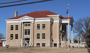
 Wallace County courthouse in Sharon Springs (2010) | |
 Location within the U.S. state of Kansas | |
 Kansas's location within the U.S. | |
| Coordinates: 38°45′52″N 101°34′33″W / 38.7644°N 101.5758°W | |
| Country | |
| State | |
| Founded | 1868 |
| Named for | W. H. L. Wallace |
| Seat | Sharon Springs |
| Largest city | Sharon Springs |
| Area | |
| • Total | 914 sq mi (2,370 km2) |
| • Land | 914 sq mi (2,370 km2) |
| • Water | 0.05 sq mi (0.1 km2) 0.01% |
| Population | |
| • Total | 1,512 |
| • Density | 1.7/sq mi (0.7/km2) |
| Time zone | UTC−7 (Mountain) |
| • Summer (DST) | UTC−6 (MDT) |
| Congressional district | 1st |
| Website | wallacecounty |

Wallace County (standard abbreviation: WA) is a county in the U.S. state of Kansas. In 2020 census, 1,512 people lived there.[1] This would make it the county in Kansas with the second-least number of people living in it. Its county seat is Sharon Springs.[2] The county was created in 1868. It was named after Brigadier general W.H.L. Wallace, who was a veteran of the Mexican–American War and a casualty of the Battle of Shiloh.
- ↑ 1.0 1.1 "QuickFacts: Wallace County, Kansas". United States Census Bureau. Retrieved October 4, 2023.
- ↑ "Find a County". National Association of Counties. Retrieved 2011-06-07.