Back Иокогама ADY Jokohama Afrikaans ዮኮሃማ Amharic يوكوهاما Arabic يوكوهاما ARZ Yokohama AST Yokohama Azerbaijani یوکوهاما AZB Иокогама Bashkir Yokohama BAN
Yokohama
横浜市 | |
|---|---|
| City of Yokohama | |
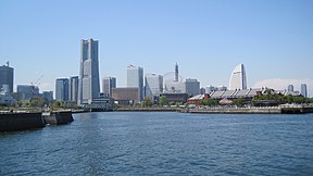
Clockwise from top: Minato Mirai 21, Nippon Maru Memorial Park, Yokohama Chinatown, Motomachi Shopping Street, Yokohama Marine Tower viewed from Yamashita Park, and Ōsanbashi Pier | |
 | |
 Map of Kanagawa Prefecture with Yokohama highlighted in purple | |
| Coordinates: 35°26′39″N 139°38′17″E / 35.44417°N 139.63806°E | |
| Country | |
| Region | Kantō |
| Prefecture | Kanagawa Prefecture |
| Government | |
| • Mayor | Takeharu Yamanaka |
| Area | |
| • Total | 437.38 km2 (168.87 sq mi) |
| Population (October 1, 2016) | |
| • Total | 3,732,616 |
| • Density | 8,534.03/km2 (22,103.0/sq mi) |
| Time zone | UTC+9 (Japan Standard Time) |
| – Tree | Camellia, Chinquapin, Sangoju Sasanqua, Ginkgo, Zelkova |
| – Flower | Rose |
| Address | 6-50-10 Honchō, Naka-ku, Yokohama-shi, Kanagawa-ken 231-0005 |
| Website | www |
| Yokohama | |||||
| Japanese name | |||||
|---|---|---|---|---|---|
| Hiragana | よこはま | ||||
| Katakana | ヨコハマ | ||||
| Kyūjitai | 橫濱 | ||||
| Shinjitai | 横浜 | ||||
| |||||
Yokohama (Japanese: 横浜, Hepburn: Yokohama, pronounced [jokohama] (![]() listen)) is a Japanese city in Kanagawa Prefecture on the island of Honshū.[1]
listen)) is a Japanese city in Kanagawa Prefecture on the island of Honshū.[1]
Yokohama is the capital of Kanagawa Prefecture in the Kantō region. Yokohama is a neighbor city of Tokyo. It has been the second largest city of Japan since the 1980s.
Yokohama has an international trade seaport. It is the largest port in Japan. Many cars and machinery are exported from the port. The downtown area is around the port. Today, the area of Yokohama city includes its former suburb areas like Hodogaya or Totsuka.
In Minato Mirai, there are a lot of places for sightseeing. For example, there are amusement parks and shopping malls.
Yokohama was an entrance for foreign cultures for a long time. Still today Yokohama has the largest Chinatown in Japan.
The airports nearest to Yokohama are Tokyo International Airport and Narita International Airport.
Many educational institutes are located in Yokohama, including Yokohama National University and Yokohama City University.
- ↑ Nussbaum, Louis-Frédéric. (2005). "Yokohama" in Japan Encyclopedia, pp. 1054-1055.


