Back نهر تولينس ARZ Tollense Catalan Tollense CEB Tollense Czech Толлензе CV Tollense Danish Tollense German Τολένζε Greek Río Tollense Spanish تولنزه Persian
| Tollense | |
|---|---|
 | |
| Location | |
| Country | Germany |
| State | Mecklenburg-Vorpommern |
| Physical characteristics | |
| Source | |
| • location | Mecklenburg-Vorpommern |
| Mouth | |
• location | Demmin |
• coordinates | 53°53′57″N 13°1′57″E / 53.89917°N 13.03250°E |
| Length | 95.81 km (59.53 mi) |
| Basin size | 1,799 km (1,118 mi) |
| Basin features | |
| Progression | Peene→ Baltic Sea |
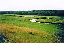
The Tollense (German pronunciation: [tɔˈlɛnzə], from Slavic dolenica "lowland, (flat) valley"[1]) is a river in Mecklenburg-Vorpommern in northeastern Germany, right tributary of the Peene. It has a total length of 95.8 km.
The upper course begins near a small lake named Mürzsee, near the village of Blumenholz. A part of it is traditionally called Ziemenbach, flowing to lake Lieps. From this lake to Lake Tollense (Tollensesee) it is nowadays called Liepskanal. The section from Lake Tollense to the junction with Peene river near Demmin has a length of 68 km. At this junction, the discharge and basin of Tollense is larger than the discharge and upstream basin of Peene river.
The first kilometer of the outflow in Neubrandenburg is called Oberbach. Afterwards, it is reached by two major tributaries, Linde river from the east and Malliner Wasser from the west. The middling section of Tollense river is joined to Zarow river by three different Pseudo-bifurcations.
- ^ Schlemmer, K. (1906). Geographische Namen. Erklärung der wichtigsten im Schulgebrauche vorkommenden geographischen Namen (in German). Leipzig: Rengersche Buchhandlung Gebhardt & Wilisch. p. 88.