Back Victoria-Wes Afrikaans Victoria West German Victoria West Estonian Victoria West French Victoria West Italian Victoria-Wes Dutch Victoria West NSO Victoria West Polish Victoria West Romanian 西維多利亞 Chinese
Victoria West
Victoria-Wes | |
|---|---|
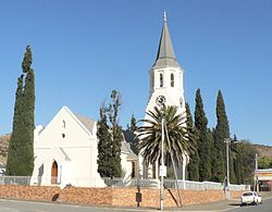
 Dutch Reformed Church, Victoria West | |
| Coordinates: 31°24′11″S 23°07′14″E / 31.40306°S 23.12056°E | |
| Country | South Africa |
| Province | Northern Cape |
| District | Pixley ka Seme |
| Municipality | Ubuntu |
| Established | 1844[1] |
| Area | |
| • Total | 78.95 km2 (30.48 sq mi) |
| Population (2011)[2] | |
| • Total | 8,254 |
| • Density | 100/km2 (270/sq mi) |
| Racial makeup (2011) | |
| • Black African | 23.7% |
| • Coloured | 69.3% |
| • Indian/Asian | 0.4% |
| • White | 5.6% |
| • Other | 0.9% |
| First languages (2011) | |
| • Afrikaans | 82.1% |
| • Xhosa | 13.8% |
| • English | 1.1% |
| • Other | 3.0% |
| Time zone | UTC+2 (SAST) |
| Postal code (street) | 7070 |
| PO box | 7070 |
| Area code | 091 |
Victoria West is a town in the central Karoo region of South Africa's Northern Cape province. It is situated on the main N12 route, at an elevation of 1,300 metres (4,300 ft). It is the seat of the Ubuntu Local Municipality within the Pixley ka Seme District Municipality.[3]
- ^ Robson, Linda Gillian (2011). "Annexure A" (PDF). The Royal Engineers and settlement planning in the Cape Colony 1806–1872: Approach, methodology and impact (PhD thesis). University of Pretoria. pp. xlv–lii. hdl:2263/26503.
- ^ a b c d "Main Place Victoria West". Census 2011.
- ^ Victoria West, Heart of the Karoo, retrieved 2009-02-02


