Back Villiersdorp Afrikaans Villiersdorp German Villiersdorp Estonian ויליירסדורפ HE Villiersdorp Hungarian Ֆիլլիրսդորպ Armenian Villiersdorp Italian Villiersdorp Dutch Villiersdorp NSO Villiersdorp Romanian
Villiersdorp | |
|---|---|
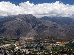
 View of Villersdorp from the surrounding mountains | |
| Coordinates: 33°59′27″S 19°17′22″E / 33.99083°S 19.28944°E | |
| Country | South Africa |
| Province | Western Cape |
| District | Overberg |
| Municipality | Theewaterskloof |
| Established | 1841[1] |
| Area | |
| • Total | 2.89 km2 (1.12 sq mi) |
| Population (2011)[2] | |
| • Total | 10,004 |
| • Density | 3,500/km2 (9,000/sq mi) |
| Racial makeup (2011) | |
| • Black African | 40.3% |
| • Coloured | 44.7% |
| • Indian/Asian | 0.2% |
| • White | 12.5% |
| • Other | 2.3% |
| First languages (2011) | |
| • Afrikaans | 56.5% |
| • Xhosa | 24.6% |
| • Sotho | 12.8% |
| • English | 3.4% |
| • Other | 2.7% |
| Time zone | UTC+2 (SAST) |
| Postal code (street) | 6848 |
| PO box | 6848 |
| Area code | 028 |
Villiersdorp is a town of approximately 10,000 people located in the Western Cape province of South Africa in the Overberg region.
Unlike most of the geographical region which specialises in wheat and canola farming, the Villiersdorp Valley is now agriculturally and in micro-climate more similar to the Elgin Valley and Grabouw since the building of the Theewaterskloof Dam, and thus also specialises in deciduous fruit farming and viticulture. The Theewaterskloof Dam, the largest dam in the Western Cape and seventh largest in South Africa and important water supply to Cape Town fills the majority of the valley floor. The Villiersdorp Co-Op is also the only place in South Africa that processes and dries persimmons. The three big packsheds in Villiersdorp, Betko, Arbeidsvreugd and Ideafruit, as well as the Villiersdorp Co-Op process the fruit grown in the area for export and transport to other parts of South Africa. The town is named after Field Cornet Pieter de Villiers, a local farmer who founded the settlement in 1843. There is a lot more packsheds that developed over the years like Fruitways , Provider farming, Vilbo Fruit, Fruit Affair, Kaaimansgat boerdery, Bo Radyn Boerdery, that are not mentioned.
- ^ Robson, Linda Gillian (2011). "Annexure A" (PDF). The Royal Engineers and settlement planning in the Cape Colony 1806–1872: Approach, methodology and impact (PhD thesis). University of Pretoria. pp. xlv–lii. hdl:2263/26503.
- ^ a b c d "Main Place Villiersdorp". Census 2011.

